

You can find on this page the Switzerland region map to print and to download in PDF. The Switzerland political map presents states, regions, provinces and surrounding areas of Switzerland in Western Europe.
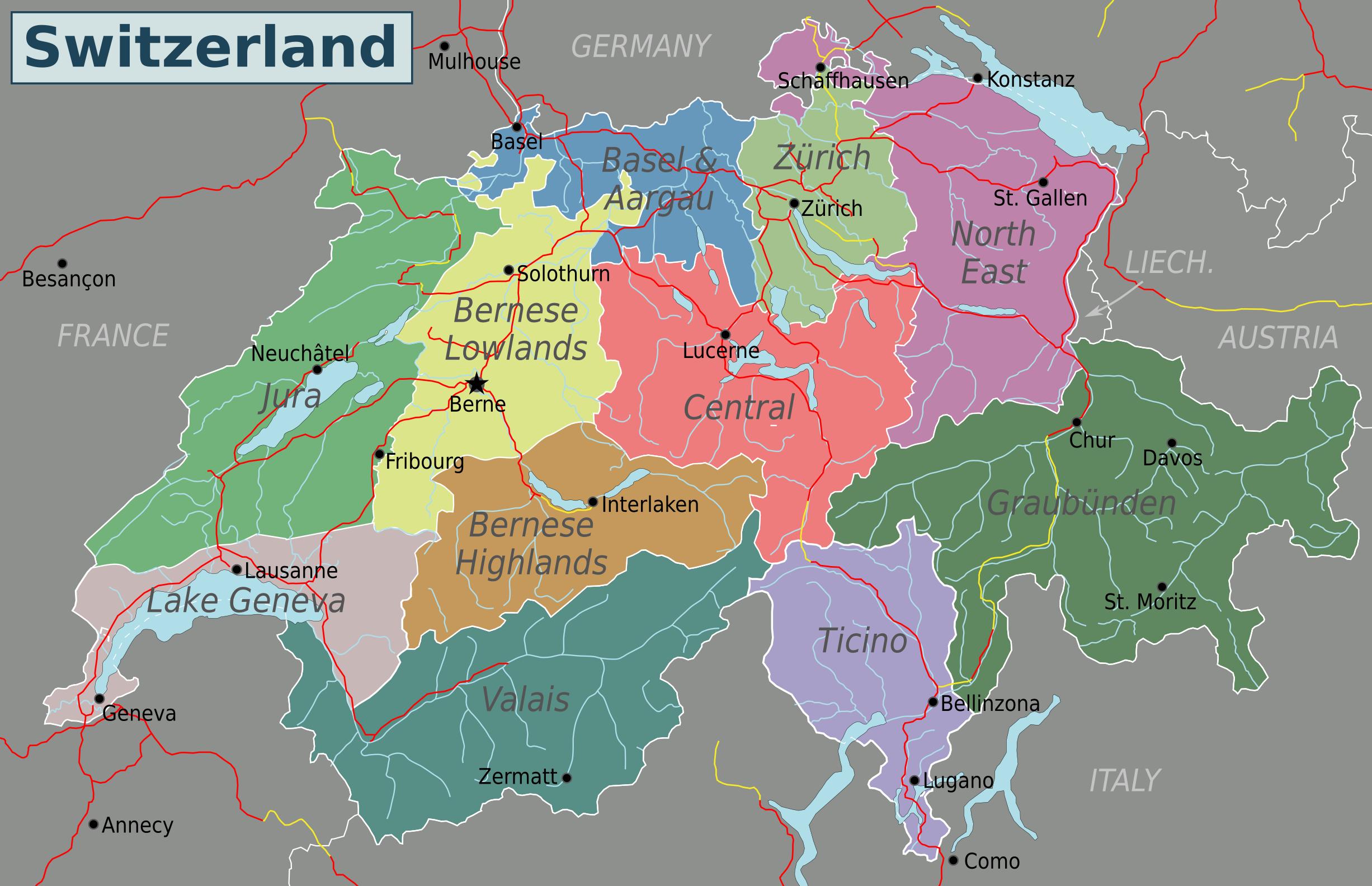
The Switzerland regions map shows surrounding areas and provinces of Switzerland. This administrative map of Switzerland will allow you to know regions of Switzerland in Western Europe. The Switzerland regions map is downloadable in PDF, printable and free.
For statistical purposes, Switzerland is subdivided in seven region at the NUTS-2 level as you can see in Switzerland regions map: Eastern Switzerland: Cantons of St. Gallen, Thurgau, Appenzell Innerrhoden, Appenzell Ausserrhoden, Glarus, Schaffhausen, Graubünden. Zürich: Canton of Zürich. Central Switzerland: Cantons of Uri, Schwyz, Obwalden, Nidwalden, Lucerne, Zug. Northwestern Switzerland: Cantons of Basel-Stadt, Basel-Landschaft, Aargau. Espace Mittelland: Cantons of Bern, Solothurn, Fribourg, Neuchatel, Jura. Région lémanique: Cantons of Geneva, Vaud, Valais. Ticino: Canton of Ticino.
Eastern Switzerland (German: Ostschweiz) is the common name of the region situated to the north of Glarus Alps as its shown in Switzerland regions map. The north of canton Graubünden (with the city of Chur) is sometime considered to be part of Eastern Switzerland. The region of Zurich has a population (as of 31 December 2011) of 1,390,124. The region is located in the northeast of Switzerland and the city of Zurich is its capital. The official language is German, but people speak the local Swiss German dialect called Züritüütsch. In English the name of the region is often written without an umlaut. The region of Ticino is where you can experience the Italian speaking part of Switzerland, including its food and culture. It is the most southern part of Switzerland along with the Valais. The Ticino is one of the places to enter or leave Switzerland if you plan to travel in Italy as well.
Central Switzerland is the region of the Alpine foothills geographically the heart and historically the origin of Switzerland. is dominated by Lake Lucerne, with the pre-Alps north of it and the Bernese Alps south of it as its mentioned in Switzerland regions map. Lucerne, with its pretty old town center, is the main town in Central Switzerland. Northwestern Switzerland (German: Nordwestschweiz) is the common name of the region of Switzerland. It includes the city of Basel, the Jura and the Three-Lakes region of Neuchâtel and Biel/Bienne. It borders to France and Germany. For many travelers, North-West Switzerland is where they enter the country. Bern region is part of what is called the 'Schweizer Mittelland', or Swiss Plateau. The landscape is relatively flat. The region is located between the Jura mountains in the north-west and the Alps in the south-east. Zurich is part of the Swiss Plateau as well.
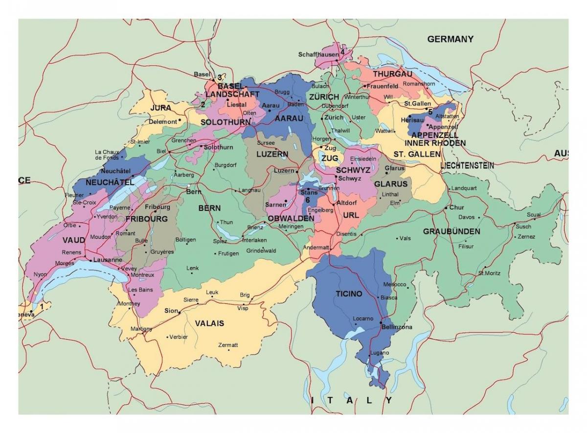
The Switzerland political map shows regions and provinces of Switzerland. This administrative map of Switzerland will allow you to show regions, administrative borders and cities of Switzerland in Western Europe. The Switzerland political map is downloadable in PDF, printable and free.
The politics of Switzerland take place in the framework of a multi-party federal parliamentary democratic republic, whereby the Federal Council of Switzerland is the head of government (see Switzerland political map). Executive power is exercised by the government and the federal administration and is not concentrated in any one person. Federal legislative power is vested in both the government and the two chambers of the Federal Assembly of Switzerland. The judiciary is independent of the executive and the legislature. For any change in the constitution, a referendum is mandatory; for any change in a law, a referendum can be requested. Through referenda, citizens may challenge any law voted by federal parliament and through initiatives introduce amendments to the federal constitution, making Switzerland the closest state in the world to a direct democracy.
Switzerland government has been a coalition of the four major political parties since 1959, each party having a number of seats that roughly reflects its share of electorate and representation in the federal parliament. The classic distribution of 2 CVP/PDC, 2 SPS/PSS, 2 FDP/PRD and 1 SVP/UDC as it stood from 1959 to 2003 was known as the "magic formula" as you can see in Switzerland political map. This "magic formula" has been repeatedly criticised: in the 1960s, for excluding leftist opposition parties; in the 1980s, for excluding the emerging Green party; and particularly after the 1999 election, by the People Party, which had by then grown from being the fourth largest party on the National Council to being the largest. In the elections of 2003, the People Party received (effective January 1, 2004) a second seat in the Federal Council, reducing the share of the Christian Democratic Party to one seat.
Switzerland has a rich party landscape. The five political parties represented in the Federal Council are generally called the government parties as its shown in Switzerland political map: Free Democratic Party, Social Democratic Party, Christian Democratic Party, Swiss People Party, and Conservative Democratic Party of Switzerland. As of 2011 only the five government parties were represented in the Council of States. In the National Council the party landscape is more diverse with eight non-government parties having at least one seat. In recent years, Switzerland has seen a gradual shift in the party landscape. The rightist Swiss People Party (SVP), traditionally the junior partner in the four-party coalition government, more than doubled its voting share from 11.0% in 1987 to 22.5% in 1999, thus overtaking its three coalition partners. This shift in voting shares put a strain on the "magic formula", the power-broking agreement of the four coalition parties.

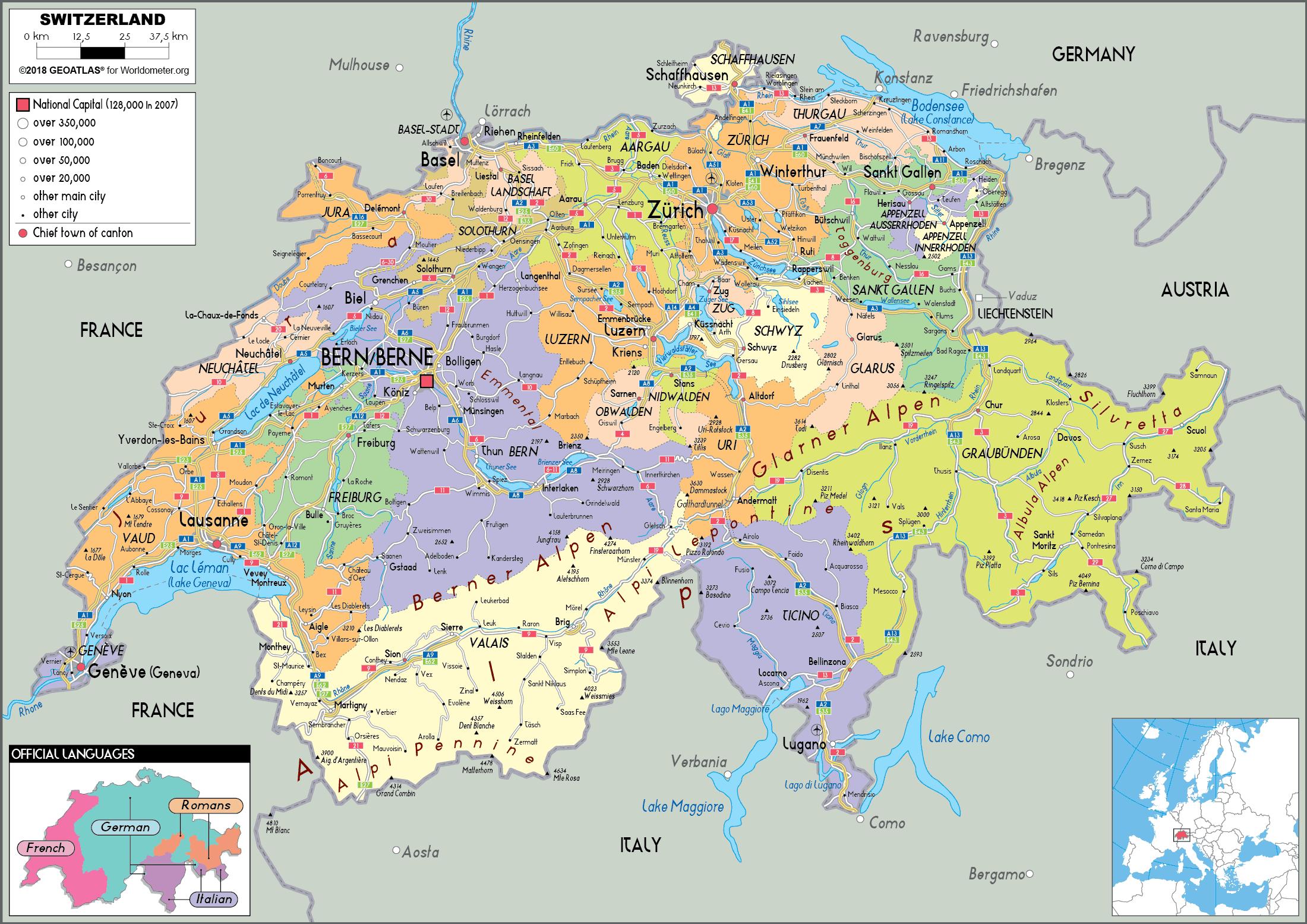
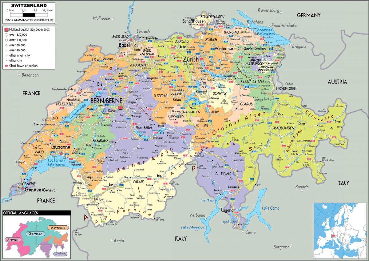
The Switzerland states map shows all departments and regions of Switzerland. States map of Switzerland will allow you to know areas and cities of Switzerland in Switzerland. The Switzerland states map is downloadable in PDF, printable and free.
The Swiss Confederation consists of the 26 cantons or states of Switzerland. Each canton has its individual structure for further subdivisions. The 26 cantons of Switzerland are the member states of the federal state of Switzerland. Each canton was a fully sovereign state with its own borders, army and currency from the Treaty of Westphalia (1648) until the establishment of the Swiss federal state in 1848 as its mentioned in Switzerland states map. The most recently created canton is the Canton of Jura, which separated from the Canton of Bern in 1979. The name is derived from the French language word canton meaning corner or district (from which the term Cantonment is also derived). In the 16th century, the Old Swiss Confederacy was composed of 13 sovereign cantons, and there were two different kinds: six land (or forest) cantons and seven city (or urban) cantons. Though they were technically part of the Holy Roman Empire, they had become de facto independent when the Swiss defeated Emperor Maximillian in 1499. The six forest cantons were democratic republics, whereas the seven urban cantons were oligarchic republics controlled by noble families.
Each canton or state in Switzerland has its own constitution, legislature, government and courts. Most of the cantons legislatures are unicameral parliaments, their size varying between 58 and 200 seats as you can see in Switzerland states map. A few legislatures are general assemblies known as Landsgemeinden. The cantonal governments consist of either five or seven members, depending on the canton. For the names of the institutions, see List of legislative and executive councils of the Cantons of Switzerland. The Swiss Federal Constitution declares the cantons to be sovereign to the extent their sovereignty is not limited by federal law. The cantons also retain all powers and competencies not delegated to the Confederation by the Constitution. Most significantly, the cantons are responsible for healthcare, welfare, law enforcement and public education; they also retain the power of taxation. The cantonal constitutions determine the degree of autonomy accorded to the municipalities, which varies but almost always includes the power to levy taxes and pass municipal laws. The sizes of the cantons vary from 37 km² to 7,105 km²; the populations vary from 15,471 to 1,244,400.
As on the federal level, all Switzerland states provide for (half-) direct democracy. Citizens may demand a popular vote to amend the cantonal constitution or laws, or to veto laws or spending bills passed by the parliament. General popular assemblies (Landsgemeinde) are now limited to the cantons of Appenzell Innerrhoden and Glarus. In all other cantons democratic rights are exercised by secret ballot. Six of the 26 cantons are traditionally, but no longer officially, called "half-cantons" (German: Halbkanton, French: demi-canton, Italian: semicantone), reflecting a history of mutual association or partition as its shown in Switzerland states map. The enlargement of Switzerland by way of the admission of new cantons ended in 1815. After a failed attempt of Vorarlberg to join Switzerland in 1919, the idea of resuming Swiss enlargement was revived in 2010 by a parliamentary motion that would allow the accession of regions bordering on Switzerland.